Do you think the oil spill in the gulf will kill...

Tuesday, February 1, 2011

Bad news


I will no longer be posting anything weather on here unless it's in the south atlantic.

Oh, and I am posting this picture for another site.

Monday, August 23, 2010

Danielle is a hurricane!

I really don't have that much time to go into detail. Heck, virtually noone sees my blog.

Wednesday, August 11, 2010

Tropical depression Five in the gulf

From the new loops from NOAA, it appears that Tropical Depression Five has been created. It will not become a hurricane, but with another sudden storm in the season, I really hope that Alabama and Mississippi are ready. Honestly I don't think that it will do that much damage because of how it looks right now on NOAA's weather loops. I have a link to those webpages in the sidebar somewhere.

When I first saw it I wasn't even able to make out a storm in that mass of spinning cloud. I daresay it took me half-a-minute to find it's COC! (center of circulation) If it's that disorganized, I predict it will not get that strong.

Tuesday, August 3, 2010

Tropical storm Colin

Colin
The fourth tropial storm of the year in the Atlantic has come. Usually it's a D storm but remember tropical storm Abrew (Anita) in the south atlantic. So I didn't skip a thing (except maybe the formation of the storm). This NOAA image has just revealed the sun on this system.
As of where it's going is uncertain, with my predictions take it just missing landfall seven days from now as a Category two storm, and NOAA's forecast taking Colin 100 miles east of that. But right now, NOAA's predictions seem wrong because it's already starting to slip south of the forecast 12 hour mark.
With the strength of the storm right now being 40 miles per hour, that is subject to change, being over warm waters of 28 degrees celsius. It's going to become 29 degrees celsius, so don't be surprised if it's a hurricane in any part of its lifetime.

Friday, July 23, 2010

Bonnie has made landfall

In Miami Beach, a storm named Bonnie is making it's wrath, but only with 40 mph winds. I'm surprised if anyone dies, but not if there's injurys. This is still a pretty big deal for Florida, though. Exactly 24 hours ago, it was first recognized. This is so abrupt.

But even though the big shock, the storm has a 20 percent chance of dissipating.
A picture of the upper level divergence
The upper level divergence and lower convergence are very inequal. There's not much Lower level convergence, but upper divergence is different. This inequality could tear the storm apart. But that doesn't mean that Bonnie is nothing. Louisiana still needs to take cover.

Bonnie about to make landfall

Tropical storm Bonnie is about to take landfall in Miami Beach, Florida.

Bonnie aproaches Florida


This CIMSS image downloaded onto Google Earth indicates that Bonnie has finished it's wrath with Grand Bahama, and is now aiming at Florida. I am very worried on whether or not this will be destructive, though only a tropical storm. I do not think this will have a chance to make it to hurricane strength, though. I will be shocked if it does.
Deepwater Horizon has to take cover as well as Miami. The outer bands of Bonnie will most likely hit far north of the storm, hitting Gainsville with tornadoes at worst. Then the outer band will swing infront of the storm, hitting Deepwater Horizons very hard, with winds in excess of 60 miles per hour at most. There might be tornadoes there, too. Deepwater Horizons is starting the ultimate test of riding out the storm. Although, this very well may be our last Gulf storm of the season.
After Deepwater Horizons, New Orelands is next. It will already be weakened to about 45 miles per hour, though, so the storm shouldn't swallow the city as with Katrina and Gustav.
Take cover!

Thursday, July 22, 2010

Bonnie


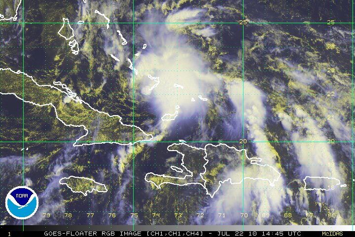
This image of Tropical Storm Bonnie (lower right) is an image from cimss, which I used for Google Earth.


A lot of models forecast for no landfall in Florida. I respectfully disagree, saying that Bonnie will landfall in Miami in ten hours or so. By 36 hours, Bonnie emerges, but only for another thirty six hours, calling for a maximum strength of just 55 miles per hour, a rather weak tropical storm.


Bonnie might test to see just how quick Deepwater Horizons can prepare. I personally hope that it doesn't get too hard, because it may very likely screw up the temporary fix in the hole, sending the Earth bleeding again.


I do think that because of the screwed oil rig, this season might be the most deadly long-term effective in Atlantic history. Just the third named storm (the first two Abrew (90SL) and Alex) is threatening BP.


Bonnie, though only having <5%>

Noone knows for sure. But if Bonnie really is gonna pick the world up and gonna drop it on BP's head, BP needs to put their helmet on. (Not literally.)

TD#3!

Tropical depression three has formed in the Caribbean sea. I've been tracking the precursor to this storm for a week. It was just a lower level low with no upper or middle level winds. It was over cold waters in a dry enviornment. It's strange that it has come that far.
It was found by the center of circulation being smack-crap-that in the middle of a bahamian weather station. It's forecast is to travel over florida, into the gulf of mexico, and threatening deepwater horizions.
I will be going to the dentist. When I come back I'll give more info.


-Chief of W.A.H.A-