Do you think the oil spill in the gulf will kill...

Saturday, May 31, 2008

Arthur!


Arthur has formed! I can't believe it! That very disorganized storm has actually transformed into a tropical storm! There is a reason to talk about Alma after all. This is amazing. A tropical storm has formed over land. I have waited for this day for a long time for this. Anyway, this storm is going to strengthen, I predict.
Arthur:
40 mph winds
1008 mlb
moving West

90 hit belize


Belize has been hit by 90, and 90 is now passing by Belize, and is moving to Mexico. Invest 90 will survive crossing the Yucatan peninsula, due to the well definition of the storm, and the fast winds of 35 mph. After that, 90 will strengthen to a tropical storm, and then to landfall in Mexico. this will all happen before June 3rd. I am very exited! I can finaly track an Atlantic storm!

ProtoArthur

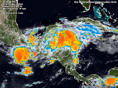
Waha is now officiallly recognizing 90 as a real invest. It's circulation is perfect, 90 is in not a lot of wind shear, 90 is very dense, and actually spinning at 30 mph, if not, more than that wind speed. I can't wait until this storm becomes Arthur. That would give me a reason t otype about Alma. The remnants from Alma actually formed a storm! From the Eastern Pacific ocean to the North Carribean, this storm is really investing, and by investing, I mean forming. Invest 90 is thriving in existence and will form Arthur by tomorrow unless landfall which will disrupt 90 so that Arthur would form, in the Gulf of Mexico, and not the Northern Carribean. If 90 is slowmoving enough, 90 will become Tropical Depression One, but wil get torn apart by the wind shear that will eventually cause 90 to weaken, I typed eventually because there will be slow wind shear, the kind that takes its toll overtime so the tropical storm or hurricane has a few days to live.
If Arthur is to form, Arthur will most likely form in the Gulf of Mexico, where there isn't a lot of wind shear compared to the Carribean, and also in aadittion with that, the waters are very warm. Waters are also warm in the Carribean, in fact, the waters are warm enough in the Carribean sea to support hurricanes all year long. But despite the warm waters, there is often alot of wind shear, which seasonally comes every off season. The gulf of mexico usually has cold waters in its north, warm in the south, but has relativaley no wind shear May 1st through December 10th.
I recommend that people in belize evacuate, the storm is about to landfall on you guys.

Friday, May 30, 2008

Investing again, eh?


Alma has dissipated completely now, but another storm has formed within the eye. Waha names it Invest90L mark two. 90 will continue to move in deeper to the North Carribean. Also, this storm will slam into the northern part of Belize, then moving into the gulf of Mexico, strengthening to a maximal tropical storm, before reaching Mexican territory.

Alma 100% chance

Alma has followed my prediction so far. Alma will become atlantic I swear! Just go with the last prediction I made and you're fine.

Thursday, May 29, 2008

Alma expected to turn atlantic


Tropical storm Alma won't recurve that much. But, there is a chance of the 2008 hurricane season:
  • Starting with Alma not Arthur
  • Having an off season storm
  • The first ever season to have it's first storm form in the pacific
  • There is an eighty percent chance Alma will set records by traveling into the Atlantic, and a twenty percent chance Alma won't do that.

    As Alma makes her second landfall at 63 mph, major flooding is happening in the Central Americas. Alma will continue to do that until approaching the North Carribean sea, Landfalling a third time into Belize, all promptly before reaching the Gulf of Mexico, rapidly strengthening to a minimal hurricane. And then the grand finale landfall, marking Alma's fourth landfall (since being an unorganized wave in Panama,) in Central Mexico, just barely reaching Mexico City, Mexico. All of that is going to happen in the next three short days. But for now, Alma is taking landfall in Central America.

    Brought to you by Waha.

    ALMA!


    Alma has formed!
    Wind speed 40 mph
    I predict that alma will arrive shortly to land. After the landfall, I will predict Alma traveling into the North Carribean sea and rapidly intensifying. Alma will strengthen overland, mysteriously. Some storms do that, such as Olga of 2007, and Wilma of 2005. That's because at those times, those storms were undergoing an eyewall replacement cycle. That's just what is happening with Tropical storm Alma. If this storm travels into the Atlantic, the 2008 hurricane season will actually start with Alma instead of Arthur!
    There is Major flooding in Costa Rica , even though Alma has already hit that place!
    (by the way, Invest 90 is no more, just as the opposite of what i swore, but at least those storms were twins,)

    Hello what is this?

    TD One has formed, with Invest 90 right next to it! I don't know how this happened, but in the
    picture, the eye to the north is td1E, and the other eye to the south is 90. Yet there is no fujiwara effect to stop this! How did this happen?

    Wednesday, May 28, 2008

    Landfall

    Costa Rica is okay, right?

    Thirty at last!

    Invest 90 has now gone into better circulation and is now up to 30mph. It is heading towards Costa Rica, so Costa Ricans, be ready. Even though it is off season doesn't mean a storm is not gonna hit you guys.
    It so happrns that 90 is going to form as an Arthur. It's going east north east at 3 mph; into Costa Rica. After that weak landfall, I predict it's going to strengthen to Arthur, but before the fall, 90 will be td1.
    Poor Costa Rica, needs to prepare for Eastern pacific hurricane season, and Atlantic hurricane season.

    Tuesday, May 27, 2008

    West winners

    The west part of the invest was dominate of sucking in the other eye, which I discovered wasn't really an eye after all! Waha now recognizes invest 90 as a storm with well defined circulation. Also, Waha reccomends an evacuation plan in South America and Panama, which the storm is whamming into, or at least it's in 90's way.
    For those in West Columbia and Panama, make sure you're prepared.

    The opposite of well defined circulation

    The other part of the wave is in the south carribean sea, more east of the other part of 90L. I outlined the wave in blue and circled the two eyes of Invest90. 90 has two eyes, yesterday having one eye.
    The eastern part of 90L is more slowmoving. If TD 1 were to form, it's probably not forming here because of the incoming warm front. Lets hope it does form because I have waited a helluva long time for Arthur. Please, 90L, you know you want to form in the atlantic as Arthur, right?

    It means storm not bank


    We have found an "Invest" called 95L. I was right! I knew the panamaiian showers would wither away, but I didn't know this wave was going to be named! This storm went from a disorganized wave to an organized, spinning, strengthening storm.
    I swear this invest will become Td1.

    Monday, May 26, 2008

    The hurricane of the week


    Super Hurricane Katrina 2005
    The most Destructive hurricane ever to hit TUSOA (the united states of america)
    With 175mph winds, Katrina was a fierce category five-a super hurricane on the saffir simpson
    scale. She was molesting New orelands like the crapping hurricane it is.

    Tropical waves way out

    I have noticed a spinning wave Way out of whack-it doesn't spin, it's in a tono' wind shear, and not that dense. However, this wave is a big threat to Panama. But these panamaiian showers are to clear up tomorrow.
    The wave is expected to plunge to deexistence rapidly. There are other waves, but all of them are over shear and cold water. No formation is expected in the next 96 hours. But don't worry anyway, because there is a long time left of Offseason-122 hrs and 53 minutes.

    Welcome

    This site will allow you to find out what is going on in the Atlantic ocean, with descriptions of waves and tropical cyclones from the Wasa (weather and hurricane authority). We will try to put pictures on this blog of imfromation to help you understand these 2008 cyclones even more. We will even put down the hurricane of the week every week. But please don't be crapped if I don't put down a hurricane of the week for one of the July months, I will be on a 3 day cruise. Enjoy!