 I really don't have that much time to go into detail. Heck, virtually noone sees my blog.
Monday, August 23, 2010
Danielle is a hurricane!
I really don't have that much time to go into detail. Heck, virtually noone sees my blog.Wednesday, August 11, 2010
Tropical depression Five in the gulf
From the new loops from NOAA, it appears that Tropical Depression Five has been created. It will not become a hurricane, but with another sudden storm in the season, I really hope that Alabama and Mississippi are ready. Honestly I don't think that it will do that much damage because of how it looks right now on NOAA's weather loops. I have a link to those webpages in the sidebar somewhere.
When I first saw it I wasn't even able to make out a storm in that mass of spinning cloud. I daresay it took me half-a-minute to find it's COC! (center of circulation) If it's that disorganized, I predict it will not get that strong.
When I first saw it I wasn't even able to make out a storm in that mass of spinning cloud. I daresay it took me half-a-minute to find it's COC! (center of circulation) If it's that disorganized, I predict it will not get that strong.
Tuesday, August 3, 2010
Tropical storm Colin
Colin

The fourth tropial storm of the year in the Atlantic has come. Usually it's a D storm but remember tropical storm Abrew (Anita) in the south atlantic. So I didn't skip a thing (except maybe the formation of the storm). This NOAA image has just revealed the sun on this system.
As of where it's going is uncertain, with my predictions take it just missing landfall seven days from now as a Category two storm, and NOAA's forecast taking Colin 100 miles east of that. But right now, NOAA's predictions seem wrong because it's already starting to slip south of the forecast 12 hour mark.
With the strength of the storm right now being 40 miles per hour, that is subject to change, being over warm waters of 28 degrees celsius. It's going to become 29 degrees celsius, so don't be surprised if it's a hurricane in any part of its lifetime.
Friday, July 23, 2010
Bonnie has made landfall
In Miami Beach, a storm named Bonnie is making it's wrath, but only with 40 mph winds. I'm surprised if anyone dies, but not if there's injurys. This is still a pretty big deal for Florida, though. Exactly 24 hours ago, it was first recognized. This is so abrupt.
But even though the big shock, the storm has a 20 percent chance of dissipating.
A picture of the upper level divergence

A picture of the upper level divergence
The upper level divergence and lower convergence are very inequal. There's not much Lower level convergence, but upper divergence is different. This inequality could tear the storm apart. But that doesn't mean that Bonnie is nothing. Louisiana still needs to take cover.
Bonnie about to make landfall
Tropical storm Bonnie is about to take landfall in Miami Beach, Florida.


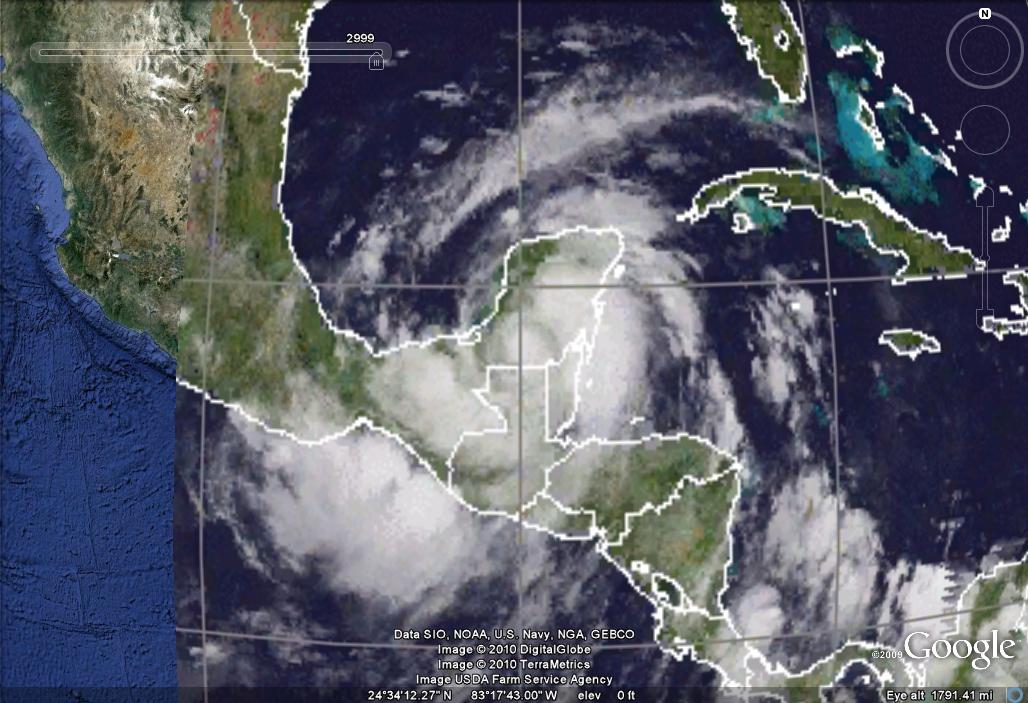
Bonnie aproaches Florida

This CIMSS image downloaded onto Google Earth indicates that Bonnie has finished it's wrath with Grand Bahama, and is now aiming at Florida. I am very worried on whether or not this will be destructive, though only a tropical storm. I do not think this will have a chance to make it to hurricane strength, though. I will be shocked if it does.
Deepwater Horizon has to take cover as well as Miami. The outer bands of Bonnie will most likely hit far north of the storm, hitting Gainsville with tornadoes at worst. Then the outer band will swing infront of the storm, hitting Deepwater Horizons very hard, with winds in excess of 60 miles per hour at most. There might be tornadoes there, too. Deepwater Horizons is starting the ultimate test of riding out the storm. Although, this very well may be our last Gulf storm of the season.
After Deepwater Horizons, New Orelands is next. It will already be weakened to about 45 miles per hour, though, so the storm shouldn't swallow the city as with Katrina and Gustav.
Take cover!
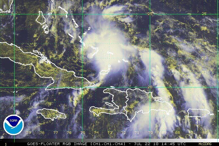
Thursday, July 22, 2010
Bonnie

This image of Tropical Storm Bonnie (lower right) is an image from cimss, which I used for Google Earth.
A lot of models forecast for no landfall in Florida. I respectfully disagree, saying that Bonnie will landfall in Miami in ten hours or so. By 36 hours, Bonnie emerges, but only for another thirty six hours, calling for a maximum strength of just 55 miles per hour, a rather weak tropical storm.
Bonnie might test to see just how quick Deepwater Horizons can prepare. I personally hope that it doesn't get too hard, because it may very likely screw up the temporary fix in the hole, sending the Earth bleeding again.
I do think that because of the screwed oil rig, this season might be the most deadly long-term effective in Atlantic history. Just the third named storm (the first two Abrew (90SL) and Alex) is threatening BP.
Bonnie, though only having <5%>
Noone knows for sure. But if Bonnie really is gonna pick the world up and gonna drop it on BP's head, BP needs to put their helmet on. (Not literally.)
TD#3!
 Tropical depression three has formed in the Caribbean sea. I've been tracking the precursor to this storm for a week. It was just a lower level low with no upper or middle level winds. It was over cold waters in a dry enviornment. It's strange that it has come that far.
It was found by the center of circulation being smack-crap-that in the middle of a bahamian weather station. It's forecast is to travel over florida, into the gulf of mexico, and threatening deepwater horizions.
I will be going to the dentist. When I come back I'll give more info.
-Chief of W.A.H.A-
Thursday, July 8, 2010
TD Two will (most likely) not be Bonnie

Good afternoon. As we speak, Tropical Depression Two is taking landfall in Mexico at the same dang place that Alex landfalled. Will that area ever get a break?
Since this storm is now overland, it is very likely that it won't strengthen, but just to let you know that it might. There were two storms in the past three years that strengthened overland. I didn't cover either of them, but nonetheless both are shocking. In fact, they were both strongest overland; Erika of 2007 (landfalled with windspeeds of 40 mph, but three days after that it had winds over 65 mph over Oklahoma), and Fay of 2008 (landfalled with 50 mph but it strengthened to 65 mph just northwest of Lake Okeechobee). So don't say that it can't strengthen to a tropical storm.
The second tropical depression of the season
An update is coming up on this almost out-of-nowhere storm. It may very well only last two more advisories, but nonetheless may become Tropical storm Bonnie.
Wednesday, June 30, 2010
Alex is now a hurricane-I post 15 hours later

Does 15 hours count as a little after? I wanted to wait until Alex was a hurricane, but never figured I'd fall asleep before the 11:00 update. I figured that just in case that happened which it did, I would set my alarm clock to 5:45 to wake me up...the next morning...it didn't work, because it somehow got unpluged from the wall!!! So here I am, typing at 8:06 pm, I just got up...don't you dare talk to me until my second cup of coffee!
As for Alex, it is now looking strong, and it's speed...compared to how Alex LOOKS right now, it's speed is a puny 80 mph. But I hardly ever look at the pressure...maybe that will improve my forecast, even though I knew it would come just south of the Texas border.
I will send further updates at 11 o'clock in the morning, not just after that.
Tuesday, June 29, 2010
Alex about to become a hurricane

Judging by this picture of Tropical storm Alex, the five o'clock update will check Alex as a hurricane. I'll check on him and make a post a little after five o'clock this evening.
Monday, June 28, 2010
Alex update

Alex has current wind speeds of 60 mph.
A surprising fact about Alex: for the past four advisories, Alex has stayed nearly in the same place! But after eighteen hours of wobbling, Alex is finally going somewhere.
Oh, and as I found out; there is no state in Mexico called Rio Grande! Oops!
I'd say if shear is kow enough, then Alex might make it to category 3 strength by Thursday. But it won't make landfall until Saturday. Again, it will landfall south of Texas.
Sunday, June 27, 2010
Alex is now in the Gulf of Mexico

Now a tropical depression, Alex has made it across the Yucatan Peninsula. A lot of people say that it will hit Texas, but I don't think so. It did make a northwest turn, though, but that trajectory doesn't put any portion of Texas in Alex's crosshairs in ant way, except that some of the rain from Alex might fall on Texas, so it can still flood. But mainly, Rio Grande is under the most threat. But Alex won't landfall there until the morning of June 30. But still, to those Mexicans that can read english or know how to Google Translate, I repeat Rio Grande is in Alex's crosshairs. And Tropical depression Alex will strengthen into a category 2 hurricane or higher, and hit Rio Grande as a hurricane as well. Seek shelter.
Alex
Tropical storm Alex has hit the Yucatan Peninsula, and apparently, crossing it fast! I'd say in the next six hours, Alex is already in the Gulf of Mexico. But it wont stay there for long.
Here's something I forgot to mention on my previous post; I am going to try to put my close up loop of Alex on Youtue. The image shown to the left is one of the frames; in fact, the most recent. The map still has crappy caliration, though.
Saturday, June 26, 2010
Alex update

Tropical storm Alex is now 60 mph. But as it nears landfall, it will loose strength, but at the 24 hour mark, it will cross into the Gulf of Mexico, and 36 hours in, it will once again become a tropical storm, and soon after, a hurricane. It might hit the Mexican state of Rio Grande, but it might hit more south. Wherever it does, it will in 3 days. Click on the image to enlarge.
Alex predictions. And one other thing...

Click on the image to see where the numbers are.
As you can see here, Tropical storm Alex has formed, with current winds of 45 mph...
Aaaugh! Fail! It should say Alex is moving westnorthwest! I should edit that...nah. Too late.
So as you can see in the picture from Google Earth (doctored to see why I made the predictions) you can see arrows. The blue arrow shows that there will be some wind shear over the system after it transitioned into the Gulf of Mexico. This should cause Alex to only strengthen to 60 miles per hour. It might become a little stronger at 65 mph. The yellow arrows show how the lower level winds might merge a little where Tropical storm Alex is going. But I may have miscalculated the points in terms of speed, shown by the red arrows.
The twelve hour mark, which is in between point "s" and point "1," is the predicted point where Alex landfalls as a tropical depression. At 36 hours, in between point 1 and 2, Alex has crossed the Yucatan by now, and restrengthened to a tropical storm again. Alex's strongest point is at or just after point 2, 48 hours. By the time Alex reaches point 3, it has weakened to a tropical depression, and then the forecast stops.
As for the oil spill in the North Gulf of Mexico, many forecasters believe that Alex will screw up the oil by miles, causing countrywide damage. But Alex isn't going anywhere near that.
Wunderground.com says that the storm will reach hurricane status, but there's too much windshear. But Rio Grande still has to take cover, so too the Yucatan Peninsula and the south tip of Texas. Tropical storms can still do extensive damage.
Alex has formed
Yes, Tropical storm Alex has formed in the north Caribbean sea, but a lot of websites say that the storm will travel northward enough to screw up the oil spill even more. I respectively disagree, as my forecast shows Alex slapping the yucatan peninsula as a tropical depression, and then instead of traveling nor'northwestward, taking a more westerly path, hitting either North Rio Grande or Southern Texas. (Rio grande is a state in mexico, F.Y.I.) I do not have pictures yet, but in an hour or two I'll give a more accurate forecast of where the storm is going to go. After all, I have changed my method of storm tracking. My method of seeing where storms will curve is based on looking at the directions of the winds of which the storm is already going towards. Then I'll see based on the winds around it whether or not those winds are go for change. After all, wind direction doesn't keep doing what it does forever, it eventually changes.
Monday, May 31, 2010

Official start of the 2010 Hurricane season!
Happy June 1st! Well, the record is now stopped, for three years now (2007, 2008, 2009) we had an early storm, but this time we have nothing early, if you do not count Tropical Storm Abrew, in the south atlantic. This is the atlantic record, right?
I can't show pictures right now, but I will probably start deleting the older posts if I run out of memory. It's just too much to... actually, maybe I'll delete the non-weather related stuff instead. Sorry for posting those cubing pictures...but I don't have a choice! I can't make another blog, I can't access the other ones, I have to do it on this one!
Hurricane Haven
I'll hopefully be part of the...do I bother saying it again? The title of the show is the title of this paragraph. It runs from 4pm eastern daylight time to 5pm eastern daylight time. For the confused, that's the time zone that New York is in. To tune in, just click the big button below. For further details, click the small button.
<> <>
As for activity in the tropics, there is not that much...
Thursday, April 8, 2010


Thursday, March 11, 2010
Abrew is "running" away
so yeah,...this is the image of Abrew. Abrew is getting picked up by the jetstream, and is still a tropical storm, it's just minimal.
 Abrew is getting picked up by the jetstream, and is still a tropical storm, it's just minimal.
Wednesday, March 10, 2010
Abrew made the transition


to a tropical cyclone this morning, and did it in bold style. This Ascat image (click to enlarge) reveals that the winds from Abrew are now closed completely, and the wind speed is still 45 mph. It is now moving away from Brazil, and from warm waters, so Abrew isn't going to be much longer.
Here's an update; NOAA has just named this storm 2 days ago as Tropical Storm 90SL. They've come up with their own naming scheme; to name the storm after the invest prior to the storm, and then remove the Q prefix (I thought it was X.) and put on SL at the back. That's strange...
Abrew set a record by the way... the first storm to have an invest prior to it with a Q, for the South Atlantic, because Q is a letter we don't usually use, as the South atlantic does not usually make tropical storms. It makes sense.
Tuesday, March 9, 2010
Subtropical Cyclone Abrew

I can't believe it! There is a subtropical cyclone in the south atlantic that's forecast to strengthen to tropical status in a couple of hours. This storm is just a subtropical depression, but the naming scheme for this basin is to give names to all storms over 29 mph. The wind speed of this storm is 35 mph, so what would be a storm in the north atlantic of that speeed being a tropical/subtropical depression, is what would be a tropical/subtropical storm in the South Atlantic. Anyway, Abrew looks like it's going to become a tropical storm, but not a hurricane. Also, I am worried about fire damage from this storm. Subtropical Storm Andrea caused a ton of fire damage when it was close to land so that's why south Brazillians should stay alert. I will give more updates later.
Monday, March 8, 2010
Invests 90X and 91X

Another invest has formed, so we have two things to watch out for. Let's go to 90X first, the storm of yesterday. It has surprisingly strengthened to having a 30% chance of cyclone formation. The jetstream...suddenly dissapears...so yet we have something else! Now there is invest 91X, which formed from an upper level low, and has joined with the other center of circulation (see yesterday's latest post) to actually have high odds of forming; a 50% chance.
Sunday, March 7, 2010
90X is weakening

I really think this storm is weakening. Sometime ago I found the center of circulation offset from the Invest. There is still some chance of development, but not that much. At best, it becomes a subtropical storm. As for the rest of the storm, it doesn't look like conditions are favorable but I suggested that there might be another center of circulation...okay I just looked at Ascat and as it turns out, there is. It's near 22 south 36 west, and it's not completely closed but it is getting there. It has maximum winds of 25 knots, and although under a moist enviornment with very warm waters, the wind shear is just too much for development. I'd take my guess back about the "Abrew" thing. I don't think there will be that much development. I will look at it by morning, but I'm sure there's just nothing to look at. Invest 90X is no longer,...but I'll update tomorrow just in case.
90X update

...advisory #4 of Invest 90X...
...I've skewd the image a little from the image of this one eumetstat weather picture. It makes it a little more to scale. It even looks like a tropical storm doing this, even though it isn't yet, yet as in could be. The red circle shows the center of circulation while the blue arrows show the upper level winds. I have to say, it is getting a little bit more organized, although the percent chance of cyclone formation dropped a percent because of the windshear. (it's going a tiny bit southsoutheast at the moment, though it looks like a lot) It is starting to form into a tropical cyclone, it is a tad bit away from being warm cored. Right now, this is not a threat to any land, but cyclones in the south atlantic are rare, only seven happening in history, the latest being "uruguay" in January 2009 (i missed it.). There is an upper level just southwest of 90X, though, that doesn't agree with it. I'm guessing it's bringing a bit of shear in the area, but that doesn't prevent 90X from forming. It certaintly wasn't the case for Zeta, in 2005-2006, where the tropical storm thrived even in windshear of twenty five knots! Even more astonishing was Zeta was over waters so cold, I would walk away from my pool if it was that cold. It was...72 degrees?... whatever, it was cold. But if the precursor to TS Zeta could do it, then so should Invest 90-X. It's only over thirteen knots of windshear and over 85 degree waters.
This will be TD One X
 This storm has surprised me. It has gone from totally unorganized to looking like future Tropical storm Abrew. I have to say I'm baffled, and in the next 48 hrs, this storm has a 90% chance of becoming a tropical cyclone...
...stay tuned for more updates on 90X...
Saturday, March 6, 2010
90x

This is surprising; 90x now has a 70% chance of becoming a tropical storm! The jetstream, shown in blue, traveled downward south, and 90x north, so there's less wind shear now, there's no dust, it's over plenty of warm water, yep... this is the first time I use my South Atlantic Naming list...
...further updates will come later in the evening, sayonara until then, stay tuned...
Invest 90-X
It has been forecasted that there is a tropical disturbance in the south atlantic right now. I don't have that good imagery available to track 90X, so I am stuck with nothing. I plan to get an image onto Google Earth, I mean the loop, of this storm so I can track it and put the video on Youtube if it turns into a tropical depression. It will be on the channel EpicAbrewFail, the exact same one as I mentioned with Epic Fail (well, actually, I had two blogs, we're the same person,). It has a lot of cubing videos there, too.
As with the prefix "X" for south atlantic storms, I didn't come up with that.
90X has been given a low (<30%)>
Tuesday, February 2, 2010
This is very offtopic from weather, but...


I have to post images of cubes on here in order to post images on my Twistypuzzles.com account.
This is my Giant Crystal Cube.
Subscribe to:
Posts (Atom)
