Do you think the oil spill in the gulf will kill...

Monday, November 17, 2008

Rene possible

Read all the direections before doing them:
  1. Click here.
  2. Click on North Atlantic water vapour.
  3. Observe the spinning storm on the right.

You will see the storm is in low shear, and is spinning at between 20-30 knots (I didn't check Quikscat yet).

Sunday, October 19, 2008

Google Earth works!

From now on, I am using Google Earth for all of my weather forecasts; and it's just in time! Invest 91 has formed, having a good chance of becoming Paloma. This system will continue to run over the yucatan peninsula for quite a while, then on the third day, this invest will have became a tropical storm, upgrading to a hurricane the next day. On day four, this system will go from cat. 1, to cat. 2, to cat. 1, to tropical storm. After that, this system mwill weaken to a tropical depression.

Wednesday, October 15, 2008

Hurricane Omar

This hurricane is moving NE very rapidly, and as I predicted, it became a hurricane. But it's no longer raging toward puerto ricco anymore.

Coming up in a week, all of my updates will be on Google Earth so that more enhancements can be made to this website. Now, you can see how well my prediction skills are increasing, by a lot at the moment.

Tuesday, October 14, 2008


Nana

Marco Laura


Kyle


And now,...
Omar!
This storm is now heading towards Puerto ricco.

Kyle, Laura, Marco, & Nana all missed but no real damage

from them, were all weird storms. Kyle took landfall in Canada as extratropical, Laura was a subtropical storm that formed higher than Vince of 2005, Marco was the smallest storm ever, and Nana, well, that wasn't unusual. But, tropical storm Omar is on it's way to Puerto ricco, not a happy storm. This system is still a depression, but it will strengthen. In my next advisory, I will show all four of those storms.

Thursday, September 25, 2008

Kyle and upper level low one

Tropical storm Kyle has formed, with the extratropical storm on it's way. Kyle will just move north, whereas the extratropical storm will landfall into Myrtle beach.

Friday, September 12, 2008

Thursday, September 11, 2008

Ike threatens Texas


Ike considerably strong


Hurricane Ike has a new target: Galveston. It's expected to hit there as a cat. 3. That will be in two and a half days.

Ike

Points are 6 hrs apart.

Wednesday, September 10, 2008

Ike

Waha has only put in a 3 day forecast this time.

Ike has made it to the Gulf of Mexico

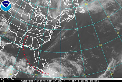
Hurricane Ike has been beatened down to a category one hurricane because Ike crossed Cuba, one point to another. I'm predicting maybe 550 deaths ffrom that storm. That's enough to make it's name retired, right? If so, Ike will be the only storm to have ever had one name with one storm only. I don't know if other storms did it or not, and I really don't care, except for the fact all those people got killed, but Ike will do that. I know this because Ike will landfall into Louisiana but hopefully will not break the dam from falling over. If it does, Louisiana is basically a time bomb with a city on it.
Tuesday, September 9, 2008

Ike has moved out to sea

Look to the map above to see where Ike is going.

Monday, September 8, 2008

Ike still moving on; Josephine struggling

Ike is going over cuba, still a hurricane, and Josepine is struggling to put itself together
Actually, Josephine is recognized as a tropical wave, that might form Kyle in the "Bahantic
sea" as I call it, meaning the area around the Bahamas is going to have favorable conditions to form Kyle.

Ike is still weakening

Today, for the five oclock update, the NOAA picture I'm using is only the Gulf of Mexico, since Ike is shown in the picture. Remember, the points are six hours apart.

ike takes landfall; something forming in atlantic


Hurricane Ike is now down to a cat. 2, and now I think it will landfall into Texas. However, there is another system right behind Ike. Wasn.t that system the same one I saw yesterday? Anyway, if this becomes Kyle, it will landfall into North Carolina.

Sunday, September 7, 2008

Ike almost at landfall

Major Hurricane ike is starting to take landfall into cuba, with winds up to 120 mph. After about 36 hours over land, Ike is absolutley to loose strength by a mile. After being bullied down to a weak hurricane or a strong tropical storm, Ike will strengthen to a strong cat. 3 or a weak cat 4.
Then, Ike will take landfall into Mississippi as a cat. 2. Well, just because I say it will hit into Mississippi doesn.t nessecarilly mean that only mississippians should leave. In fact, if Ike landfalls into Mississippi, most of the wind will go into Alabama because the winds of a hurricane always goes fastest 90 degrees clockwise of the direction of travel. However, Ike possibly won't do that, but I know it will landfall into that area as a category 2, no higher and no lower.

Ike has weakened

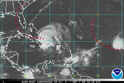
Ike has weakened a little bit, and will continue to weaken today. As Ike is still raging towards Cuba, it's already starting to take an impact on land. Today, Ike has already took a direct hit into one of the Bahama islands. In nine hours or so, Ike will be over land in Cuba. That will stay there over cuba until 36 hours from landfall when Ike heads off into the Gulf of Mexico, and then strengthen from a category one hurricane to a category four hurricane. It will not strengthen over that category, because of the windshear building up in one spot of the Gulf o' Mexico. I predict this storm will take landfall into Mississippi, as a category two, actualy, who knows? I just know it will take landfall as a category two. For more imfromation on the maps, just see last prediction.
Ike continues on; Josephine strengthening


As Ike rools to the island of Cuba,
it will weaken a bunch of strength. But I don't think Ike will go into Tampa anymore. Now, I think Ike is going to landfall into the Talahassee area, with winds of up to 150 mph. Then, Ike will go into the midatlantic reigon of the united states as it dissipates.
As with Josephine, that storm is not gonna strengthen that much higher, as it ttrevels in high windshear. Tropical depression Josephine is still a depression, but about 3 days, 4 days top, from now, Josephine will strengthen to a tropical storm. The picture shows the five day forecast, you can look at that for more info. You can also get reliable forecasts at www.wunderground.com/tropical.

Saturday, September 6, 2008

Extra sorry!

You may have heard that Waha has shut down for months because we moved. Whille I quitted, nothing stopped me from posting, and soon I thought, "What the crap am I doing?"

That made me loose so many vievs that there's a good chance you're the only one reading this entry right now, and I felt sad that all those people died because of all these storms coming.

But that was only the beginning. There are so many storms in the atlantic in September and October that Waha deleted the post saying I quit, and now I'm back and Better than ever. Now that I have my own laptop that runs so fast even with Trackmania on it (no offense, in fact that's my favourite computer game).

I'm warned about What's to come in the Atlantic. In fact, I'm so worried, That I'm now doing a 7 oclock advisory, a noon advisory(only shown on saturday), a 5 oclock advisory, and a 9 oclock advisory. Sometimes I'll do more than that.

Anyway, Ike is charging through the atlantic ocean to the WSW at a blistering pace.

Hanna, in he meantime, has finished landfall. Hanna won't do anything more serious as it weakens rapidly. However, Ike is forecast to do Quite a bit of damage over the next couple of days, but as it does so, it will weaken sharply down to a category two hurricane, but as it moves out of that area, Ike will strengthen a humongus amount; a category four hurricane (again).

Anyway, as it moves through the gulf of Mexico, it will encounter an incoming front off the coast of the Florida panhandle, that is slowly moving east. That will hopefully not, but forecast to do so anyway, make a direct hit into Tampa, Florida. That did happen with Tampa only once, the city has been pretty lucky over the past double century. Anyway, as Ike will continue to move over land and either weaken or strengthen, I don't know, I did see a hurricane strengthen over the florida peninsula. That happened in 2005 when Wilma absoluley turned Naples, Florida, into bomb remnants. I feel so sad for those victims.

As Ike becomes Extratropical, it won't do any damage, period, to any other land areas. Maybe Bermuda, but not that much. That's all I have for today. Oh yeah, one more thing, on the map every dot is six hours apart.

Thursday, July 24, 2008

Oh, crap! I missed Cristobal AND Dolly!

We are realy sorry. One, for missing Cristobal, and another missing Dolly! Well, anyway, probably not anyone got killed from Cristobal, and as only a category two storm was Dolly, maybe only killed One if really deprepared for it. Anyway, I was on vacation and the vacation happened to be over two storms.

I have some bad news. In Midaugust, Waha is shutting down for a bit if Disney hotels don't have Internet. But starting Saturday night, I think lasting ten days, I will have no bed and do you know what that means?..........(you don't, do you?) That means updates at 1200 midnight!

Wednesday, July 16, 2008

Bertha goes east


Now, Tropical storm Bertha recurved again, and Wab4E6T5, I mean, Waha,(sorry my kitten stepped on the keyboard) is knowing this storm is faraway from land and going faaaaaaaaaaaaaaaaaaaaaaaaaar away from land and weakening! Yay! I tracked a storm that was a category three and didnot affect land except Bermuda that was hit firmly!

Sunday, July 13, 2008

Bertha recurving


Here are the paths Tropical storm Bertha. The most accurate path Bertha will take is the Black one. The dots are the 24 hour marks.

Bertha has dust in her eyes


A dust storm has got Bertha right in the eye! Anyway, this tropical storm has stayed stationary all day and all of the night. This storm recurved VERY SHARPLY as a result. I think Bertha is just turning around to make a recurve towards Bermuda. That is possible. Anyway, this storm I think is safe to say this storm is an Emmi eyed storm. There's a huge eye, it's staying stationary, the majority of the clouds are pointing (barely) to the north, and the opposite side of the storm is desolving. This storm is rather tilted for an Emmi eyed storm, but it is an emmi eyed storm.

The hurricane of the week

Hurricane Epsilon
This is the other Emmi eyed storm I know.

Friday, July 11, 2008

Bertha slowly moves closer to Bermuda


Now that Hurricane Bertha has it's eyewall replacement cycle finished, it can strengthen again. By the way, sorry for the long update wait.
One more thing, a front is coming towards Bertha, so don't worry about Bertha affecting any land areas with storms if you live on the east coast. If you live in bermuda, however, Waha is issuing a Hurricane Bertha watch for your area, until twelve hours later, when the watch will turn into a warning.
Also, this is seriously bad for Bermuda since it is a small island. Hurricanes don't usually strengthen over small islands. Anyway, the front that is coming will turn Hurricane Bertha into what I call an "Emmi Eyed" hurricane.
Emmi eyed hurricanes often have a large eye with the radius of the eye being 100 mi. or more, which is like a subtropical storm. They move northeast or hardly any movement at all. An Emmi eyed storm also dissipates in about a day or two, or lose their Emmi characteristics. They have a big, thick line of clouds to the north or south depending on the hemisphere that they're in. Those types of storms tend to loose their south side if they're in the North hemisphere. As for the south hemisphere, it's the other way around.
One example of an Emmi eyed storm would be Hurricane Wilma, after it took landfall in the Yucatan peninsula. Wilma still ad it's Emmi eye when it landfell in Florida. Now, you may think there are a lot of these Emmi eyed storms. You're wrong. I've only ever seen Four; Wilma, Ioke, and Soulik. I didn't include the last one, but that one will be the Hurricane of the week.

Wednesday, July 9, 2008

Bertha strengthens


Bertha jumped: 1 to 3 to 2 to 1 to 2.


It will strengthen, and since it has passed through the jet stream, it will recurve towards North Carolina. It already started :-(.


Even though it has It's strength as a category 2, that doesn't mean it will stay like that. Bertha will strengthen.


:-( :-(


Look on the brightside! This storm is not going to have a big chance to have landfall. That's because the jet stream is inland. However, it is moving up.


Fortunatley, the jet stream is moving very slowly! That is the good news. now let's look how it did in dry air.


Look at Bertha now! Even though it's still in dry air, Hurricane Bertha is still going strong in the Atlantic. As you can see in the picture, if Bertha does make a sharp recurve to the west, then it will encounter an atmospheric eddy of which is between Florida and Bertha. The bad part about that; If it does do that, then there's a good chance there will be no update for anytime next week, as the power would go out. However that probably won't happen. Ya see, the eddy is moving upward slowly toward North Carolina! And so is Bertha!
Waha is setting advisories on Hurricane Bertha for the North Carolinian coast. Bertha might transform into a weak category four hurricane or a strong category three hurricane 12 hrs before landfall.
That is our advisory on Hurricane Bertha. We will keep you online. another update is after eleven o clock. Stay tuned!
Oh yeah, and by the way, that front that was near Bertha, hasn't done damage at all. In fact, I think that cold front connected to the low pressure system actually helped Bertha strengthen by giving it tropical moisture to help Bertha go through that inferno of dry air.


Tuesday, July 8, 2008

Bertha is now at 120 mph


Major hurricane Bertha is now blowing at top speeds of 120 mph. This major hurricane is probably not affecting landfall anytime soon. But as it goes up into less wind shear, Bertha will possibly grow to the larger side of the scale, causing Bertha to affect land areas, but since a front is going off of the USA, there's more chance of winning the lottery. The incoming low pressure system will probably be a match for Bertha, as Bertha's pressure is going up. That will probably throw some meteorologists offguard, but I will keep you started. There's gonna be a battle, if that's what the low pressure system wants! It's Bertha versus Low.
Who will win? Who will be sent down the river? If Bertha wins, will it still be Extratropical? If Low wins, will there be another perfect storm? will they both loose, and become one big spin? Tungsten? Why did I ask the question about Tungsten?
Find out, by reading my blog as Waha tracks these two storms. I'll make the updates on these storms, for you to read so that you're out of harm's way!

Monday, July 7, 2008

The hurricane of the week

Hurricane Bertha!

Rock you like the year's first hurricane!


Tropical storm bertha is no more! Bertha has strengthened into a hurricane! Unfortunatley, this hurricane will do damage to Bermuda.
It is so hard to find out what the hurricane of the week is. But now, I see a hurricane in my face! So the hurricane of the week is . . .
(scroll up)

Thursday, July 3, 2008

Bertha Has formed, with windshear low


Ten and under knots of wind shear is very favorable for Bertha to encounter. Luckilly for us that's just not gonna happen when it goes into the subtropical jet stream. But so far, it's in favorable conditions for tropical development.

tropical Depression TWO?!


I was exactly right. This didn't fail to develop. TD TWO will soon become Tropical storm Bertha.

Wednesday, July 2, 2008

banks are officially trying to confuse us this season


Invest 92L has formed. With winds at 30 mph, why can't it be named TD2?

Invest 92 is expected toform into a tropical depression. There's a 70% chance it will ever.

Monday, June 30, 2008

This wave looks suspicious


I downloaded a picture from Noaa's RGB loop. as you can see right next to their symbol, there is a tropical wave that is just waiting to be noticed. This tropical wave is in favorable conditions for tropical development. This wave is expected to try to turn into td2, maybe it will, maybe it will not. If it does develop into an invest,
I give the wave a 70% chance of maximum sustained winds depression strength, 24% chance tropical storm strength, 5% chance of sustained winds at hurricane strength, catgory 1, and category two or higher 1% chance.
This won't fail to develop. The tropical wave is in such favorable conditions.

Two hurricanes of the week

Wilma and Alpha
Wilma may have killeda lot of people, but Wilma also prevented another storm hitting the USA.
If it wasn't for Wilma, alpha would have strengthened big.

Wednesday, June 18, 2008

The atlantic is quiet.

It is June 18, 2008, and not one tropical storm has brewed in the tropics for weeks since June 2nd. However, there is a tropical wave that is likely to become a tropical storm. Waha predicts that wave to become a tropical storm eventually, but no tropical depression formation in the next 24 hours.

Tuesday, June 17, 2008

The hurricane of the week


Super Hurricane Ioke and Super Typhoon Ioke
Category 5
This storm was both a hurricane and a typhoon, I'm not talking about two storms.
Anyway, this storm tore apart wake islands, and masticated the Johnson atoll.

Saturday, June 14, 2008

The hurricane of the week


Hurricane Karen, 2007

This storm was threatening the virgin islands, with karen in it's path. Thankfully, this hurricane got masticated by wind shear and didn't hinder any weather patterns. had it kept it's strength hurricane Karen would have been Hurricane Noel, which caused more killings than Super Hurricane Katrina.

I'm back, and didn't miss anything.


The tropics have been relativaley quiet during my vacation to new york. I'm suprised I didn't miss any tropical activity, but I've been a viewer of the Weather channel and found but a single spinning subtropical wave that impacted Florida in Miamidade county, which didn't have a chance to see the vast North Atlantic ocean, even though the eastern seaboard was containing warm water and little shearing winds to completely masticate the storm.

Anyway, here's a live picture of the atlantic. There are but at least three waves. One wave is out into the central Atlantic, another near the Cape Verde islands, and the last one is making heavy rains to Puertoricco, The Dominican Republic, and Haiti. Only one of these waves are expected to strengthen into an invest and possibly a tropical depression one.(Arthur went from invest 90L straight to tropical storm strengh, without being a tropical depression.)

Thursday, June 5, 2008

No storms anywhere on this earth

Now that 91L is gone, there will be no updates here. Waha will rest until a storm has formed. I will hopefully not miss any storms to track in the atlantic friday.

Wednesday, June 4, 2008

Staying here

91L just won't leave it's current spot. 91 is just staying there, living, despite the coldblodded wind shear, over 30 knots in the carribean and rising.

Tuesday, June 3, 2008

The 91


This imagery shows 91L almost taking landfall in mexico. What I predict is that 90L will continue moving into mexico, and strengthen to td2, and maybe, Bertha. It could be another storm's name, because out in the mid atlantic, I have frequently seen tropical waves, even in the off season. By the way, storm or no storm in the Atlantic, this will become at least tropical storm status.

Monday, June 2, 2008

another change

You can also use www.wunderground.com/tropical

www.ssd.noaa.gov/goes/east/natl.html

Waha will still give you the tropical update you have come to expect, but we will now put in a loop posted on this website from Noaa. This loop will give you imformation on the tropics


The tropics in the atlantic are not as quiet as it used to be, when it was off season. I got a water vapor image from noaa, showing arthur's remnants and the rest of the west Atlantic ocean. I have noticed Arthur has completeley dissipated over the yucatan peninsula. the remnants of Arthur happened to form another storm, named 91L, which got it's name because of 90L already happening. But, eventually, an invest will have the number 90 again.

Anyway, 90L is expected to move northward into the gulf of Mexico. This storm is likely to form Bertha, the next storm "up for the bat." This Invest is already at 30 miles per hour, which depression strength is 30mph to 38 mph. But some meteorologist such as myself say it is easy to keep the storm's wind speed, or any other storm for that matter when the windspeed is rounded to the nearest 5 mph. It barely makes a difference, and it's like halfs, you know, the kind of stuff you learn in first grade. However, some meteorologists go with the real wind speed to avoid confusion.

This invest will continue to move northward, and cross Mexico, to become tropical depression two, and eventually, due to the warm water, Bertha. But for now, you mexicans better prepare for this storm coming. I hope you are, you better be, hurricane season is now. To those of you mexican people who don't know english, (HURACAN is spanish,) please translate it. you can find out easily how to translate on www.Google.com.

By the way, Waha gets these images from http://www.ssd.noaa.gov.

Sunday, June 1, 2008

Noaa lying?


I took Noaa's picture of Tropical depression Arthur, zapped it, and restored the label so that you know this is from Noaa.
This zapped shortwave is shocking to me. They really think Arthur is still overland?! HA! That can't be true! Noaa is probably tracking Arthur's arm. They don't see the mass of Arthur spinning off the coast of the Yucatan peninsula. That is where the real storm is. Staying still, huh?

The hurricane of the week

Super Hurricane Allen
the strongest atlantic basin hurricane ever recorded
Recorded winds of up to 190 mph, Allen is a mothercrapper.
Tropical storm arthur will dissipate in the next couple of days. Happy June 1st!

Saturday, May 31, 2008

Arthur!


Arthur has formed! I can't believe it! That very disorganized storm has actually transformed into a tropical storm! There is a reason to talk about Alma after all. This is amazing. A tropical storm has formed over land. I have waited for this day for a long time for this. Anyway, this storm is going to strengthen, I predict.
Arthur:
40 mph winds
1008 mlb
moving West

90 hit belize


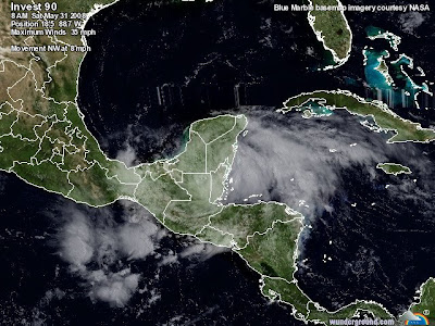
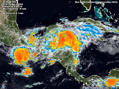
Belize has been hit by 90, and 90 is now passing by Belize, and is moving to Mexico. Invest 90 will survive crossing the Yucatan peninsula, due to the well definition of the storm, and the fast winds of 35 mph. After that, 90 will strengthen to a tropical storm, and then to landfall in Mexico. this will all happen before June 3rd. I am very exited! I can finaly track an Atlantic storm!

ProtoArthur

Waha is now officiallly recognizing 90 as a real invest. It's circulation is perfect, 90 is in not a lot of wind shear, 90 is very dense, and actually spinning at 30 mph, if not, more than that wind speed. I can't wait until this storm becomes Arthur. That would give me a reason t otype about Alma. The remnants from Alma actually formed a storm! From the Eastern Pacific ocean to the North Carribean, this storm is really investing, and by investing, I mean forming. Invest 90 is thriving in existence and will form Arthur by tomorrow unless landfall which will disrupt 90 so that Arthur would form, in the Gulf of Mexico, and not the Northern Carribean. If 90 is slowmoving enough, 90 will become Tropical Depression One, but wil get torn apart by the wind shear that will eventually cause 90 to weaken, I typed eventually because there will be slow wind shear, the kind that takes its toll overtime so the tropical storm or hurricane has a few days to live.
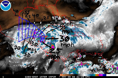
If Arthur is to form, Arthur will most likely form in the Gulf of Mexico, where there isn't a lot of wind shear compared to the Carribean, and also in aadittion with that, the waters are very warm. Waters are also warm in the Carribean, in fact, the waters are warm enough in the Carribean sea to support hurricanes all year long. But despite the warm waters, there is often alot of wind shear, which seasonally comes every off season. The gulf of mexico usually has cold waters in its north, warm in the south, but has relativaley no wind shear May 1st through December 10th.
I recommend that people in belize evacuate, the storm is about to landfall on you guys.

Friday, May 30, 2008

Investing again, eh?


Alma has dissipated completely now, but another storm has formed within the eye. Waha names it Invest90L mark two. 90 will continue to move in deeper to the North Carribean. Also, this storm will slam into the northern part of Belize, then moving into the gulf of Mexico, strengthening to a maximal tropical storm, before reaching Mexican territory.

Alma 100% chance

Alma has followed my prediction so far. Alma will become atlantic I swear! Just go with the last prediction I made and you're fine.

Thursday, May 29, 2008

Alma expected to turn atlantic


Tropical storm Alma won't recurve that much. But, there is a chance of the 2008 hurricane season:
  • Starting with Alma not Arthur
  • Having an off season storm
  • The first ever season to have it's first storm form in the pacific
  • There is an eighty percent chance Alma will set records by traveling into the Atlantic, and a twenty percent chance Alma won't do that.

    As Alma makes her second landfall at 63 mph, major flooding is happening in the Central Americas. Alma will continue to do that until approaching the North Carribean sea, Landfalling a third time into Belize, all promptly before reaching the Gulf of Mexico, rapidly strengthening to a minimal hurricane. And then the grand finale landfall, marking Alma's fourth landfall (since being an unorganized wave in Panama,) in Central Mexico, just barely reaching Mexico City, Mexico. All of that is going to happen in the next three short days. But for now, Alma is taking landfall in Central America.

    Brought to you by Waha.
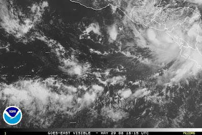
    ALMA!


    Alma has formed!
    Wind speed 40 mph
    I predict that alma will arrive shortly to land. After the landfall, I will predict Alma traveling into the North Carribean sea and rapidly intensifying. Alma will strengthen overland, mysteriously. Some storms do that, such as Olga of 2007, and Wilma of 2005. That's because at those times, those storms were undergoing an eyewall replacement cycle. That's just what is happening with Tropical storm Alma. If this storm travels into the Atlantic, the 2008 hurricane season will actually start with Alma instead of Arthur!
    There is Major flooding in Costa Rica , even though Alma has already hit that place!
    (by the way, Invest 90 is no more, just as the opposite of what i swore, but at least those storms were twins,)